
The term “polar vortex” is quickly becoming the buzzword of 2014, referring to the weather event causing the periods of extreme arctic cold affecting the country. With temperatures predicted to …
This item is available in full to subscribers.
We have recently launched a new and improved website. To continue reading, you will need to either log into your subscriber account, or purchase a new subscription.
If you are a current print subscriber, you can set up a free website account by clicking here.
Otherwise, click here to view your options for subscribing.
Please log in to continue |
|
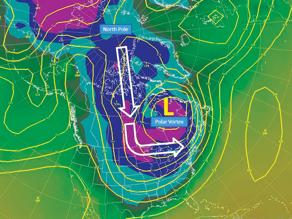
The term “polar vortex” is quickly becoming the buzzword of 2014, referring to the weather event causing the periods of extreme arctic cold affecting the country. With temperatures predicted to remain below 30 degrees for the rest of this week in Warwick, it appears as though the vortex is striking again.
But according to David Vallee, hydrologist-in-charge at the National Weather Service’s Northeast River Forecast Center, the vortex is nothing new. In fact, it happens every year.
“Every winter, there’s a very deep circulation of cold air that parks itself up near the poles,” said Vallee in a phone interview yesterday, referring to the vortex as a significant fixture around which the jet stream moves. That causes a direct correspondence with how storm systems move.
“It’s not unusual from the standpoint of we’ve never seen this before,” said Vallee. “What’s peculiar is how consistent.”
This year, the vortex has parked itself in the upper midwest portion of the United States, keeping New England directly in a cross polar flow causing the extreme cold.
Vallee explained that the vortex can be seen as a chess piece along with a number of other weather events; it usually situates itself in the northern arctic regions close to the Arctic Circle, but can fall lower. A few years ago, it was locked on the other side of the Atlantic, causing extreme cold in Europe and parts of Asia. This year, it happened to lock in to America.
Another big chess piece in the game of winter weather has been missing this year, but Vallee explained that might be a good thing. Usually, a persistent, high-pressure system over Greenland locks cold over the New England region. However, because that has not existed this year, the storms traveling to New England have been fast moving and therefore short-lived.
“As a result, while we’ve been able to maintain the cold, what we’ve seen is the storms are fast-moving,” said Vallee. “These things are getting in and out quickly.”
According to Vallee, this lack of high pressure in Greenland is why our region has yet to experience a three-day snow event such as last year’s Blizzard Nemo.
This is also the reason behind having a number of days of extreme cold, followed by a warming trend, then back to the arctic cold.
“When we lost the arctic air, we’ve gotten extremely warm,” said Vallee.
Had there been a high-pressure system over Greenland along with the low position of the vortex, things might have been much worse because the cold would have been locked. Vallee also added that climate change did not play a big role in the position of the vortex this year; it is just the way the chess pieces fell.
Recalling the incredibly snowy winter of 1995-1996 and the extreme cold of the winter of 2003, Vallee said New Englanders should not be so surprised by the extreme cold.
“About every 10 years, we should expect to see below zero temperatures; we haven’t in a while, but we should expect it,” he added.
According to Vallee, the vortex will begin to move back up north as we move through February and into March.
In the meantime, however, Vallee predicts that we are not in the clear when it comes to winter storms.
“As that shifts north, we remain in the storm track,” he said. “We’re going to stay in this pattern as we enter February.”
Vallee admits that this weather situation was not well predicted this year, but computer models looking for situations that would break up with the vortex prove that it’s not going anywhere. It just needs to make its natural progression back north, which Vallee says it will.
“We’re going to lose it, but it could take time,” said Vallee, admitting that this cold carrying over into spring cannot be predicted. “It really depends how the pattern breaks down.”
Vallee said we should expect the artic pattern to continue over the next two weeks at least, but as time goes on New England will end up on the boarder of the storm systems instead of directly in the center. That will change the type of winter storms we experience; less fluffy white snow, and more winter slush.
“We may end up with a lot more messy winter precipitation,” said Vallee.
In the meantime, Vallee and his team at the River Forecast Center are keeping an eye on the amount of river ice being created by the constant freezing, melting and re-freezing of water.
“That’s produced a remarkable amount of river ice,” explained Vallee. “It looks like the stuff’s been tossed out of an ice maker.”
Vallee explained that much of the ice has broken off in rather large pieces, some the size of picnic tables; as a result they can get stuck around sharp bends or structures such a bridges. If the ice gets jammed up, flooding can occur in those areas. Although Vallee said there have been no incidents of major flooding, he cannot recall a winter in his past four years with the Center that has led to this amount of ice.


2 comments on this item Please log in to comment by clicking here

Michael2012
Two things come to mind with his comments. First, how does he know this has nothing to with global warming. I guess he's an expert now on global warming. Second, he mentions it is good we are getting a lot of snow. As a hydrologist he should know a dry winter isn't good for the warm season regarding drought purposes. However, he is right that this is New England and expect it to be cold in the Winter.
Tuesday, January 28, 2014 Report this
Michael2012
Correction: I meant to say he mentions it is good that we ARE NOT getting a lot of snow. Biased opinion. Like I said we don't need any droughts.
Thursday, January 30, 2014 Report this